A short outline of the procedure (cf. text below):
The goal is to extract:
- Points:
- Junctions (intersections of lines)
- Dots
(isolated, circular symmetric, small point-type regions)
- Lines:
- Step
Edges (contour lines, i. e. common boundary of two regions)
- Bar
Edges like drawings (elongated, line-type regions, maybe isolated or open, i.e. not
connected to other lines)
- Blobs:
- homogeneous image regions
- Topological neighborhood relations between the features
(In case some of the features or the relations are not necessary for the application
any selection or combination can be defined by the users in the control file of FEX.
It is also possible to use the edge pixel chains instead of
the chain approximation, i.e. the polygons).
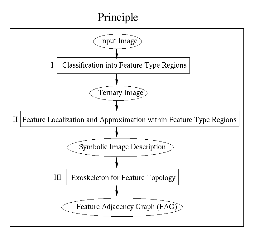
The FEX procedure consists of three main parts:
- Extraction of
point areas and line areas of interest. These areas indicate the
approximate location of the different feature types
- Location of points
and lines with high accuracy within the point and line areas of interest. And,
the approximation of line pixel sequences (chains) and blob boundaries
by analytic functions (here straight lines)
- Extraction of neighborhood relations between the features.
1. Step: Classification
Homogeneity:
The definition of homogeneity is based on the gradients of the image
function. In the TESTPTATTERN image and also in the other examples of
this demo the image function is simply the intensity function, but
the concept of FEX allows also to define the image function by colour
or texture. E.g.. the homogeneity criteria is defined for an arbitrary
number of input channels, thus works also for the RGB-space.
We model the observed
greylevel g(r,c) of the pixel at position (r,c) to be the real
(noise-free) greylevel f(r,c) overlayed with image noise n(r,c), thus
g(r,c) = f (r,c) + n(r,c).
n(r,c) is assumed to be signal
dependent and POISSON distributed. We estimate the image noise within
FEX automatically. This allows later to define, also automatically, the
signal dependent thresholds of the homogeneity criteria, which are
e.g. required for the extraction of the regions.
Shape:
Non-homogeneous image areas are analyzed further for
the shape of inhomogeneity: Similar gradient directions within a local
neighborhood indicate that we have a linear feature (step edge or line
edge), changing gradient directions within a local neighborhood,
e.g. a high curvature, indicate a point type feature (corner, junction,
dot).
Output of 1. Step: Ternary Image
Given the input
image we first calculate the homogeneity measure and shape measure for
each pixel. This leads to two (iconic) feature images. We are then
able to classify at each image position, whether the pixel lies in a
homogeneous blob, or whether the pixel belongs to, or is influenced by
a line type feature or by a point type feature, thus belongs to a
point region or a line region. This classification leads to the
''3-feature-class-image'', the Ternary Image.
2. Step: Feature Location:
Within the point-type and the
line-type-areas, indicated in the Ternary Image, the estimation
procedures of the accurate position of the points and the lines takes
place. A set of iconic feature images is necessary to find the best
positions of points and line points. (cf. Claudia Fuchs: Image
Segmentation in: Second Course for Digital Photogrammetry,ipb, Bonn,
1994). Sequences of line points are finally approximated by straight
lines (i.e. line segments, polygons).
Applying a connected components algorithm for all homogeneous areas of
the Ternary Image directly leads to the blobs. Similarly to the lines,
the blob boundaries (including the blob holes) can be approximated by line
segments (here always closed polygons).
Output of 2. Step: Symbolic Feature Description
All
features are described by their geometric and/or radiometric
properties, also including quality aspects, e.g the covariance matrix
of the point coordinates as a measure of the geometric accuracy of the
points, or the variance of the greylevels within the blobs as a
quality measure of the blob homogeneity. The features are stored
in lists, thus we now have a vector type or symbolic description of
the image structure.
3. Step: Neighborhood Relations
To estimated the neighborhood relations between the features, we
build up a label image of all features and calculate the exoskeleton
(the Voronoi Diagram) in the label image. The surrounding areas of the
features bounded by the exoskeleton lines are called feature regions.
Each exoskeleton line
indicates a neighborhood relation between two features, the nodes of
the exoskeleton indicate the neighborhood of at least three features.
The neighborhood relations are characterized by some attributes: e.g.
to describe the connectivity or the strength of a neighborhood
relation we calculate and store the length of the exoskeleton line
between the two features.
Output of 3. Step: Feature Adjacency Graph FAG
We
collect all relations derivable by the exoskeleton. Then, features and
neighborhood relations define an attributed planar graph, the FEATURE
ADJACENCY GRAPH, where the features correspond to the graph nodes and the
neighborhood relations correspond to the graph edges. The FAG is saved
in a ASCII FILE in the ''Global Exchange Format''
(cf. FEX home page),
including the image characteristics (e.g. the image noise),
and also the defined control parameters.