A main issue in geosciences is the study of the landscape's hydrology. The term hydrology is derived from the Greek meaning water and reason, hence hydrology is the science of water,
including its discovery, uses, control and conservation. The never-ending circulation of
water and water vapor over the entire earth is known as hydrologic cycle,
being the so-called runoff one of the most important processes involved in it. The word runoff refers to
the flow of water over the earth surface. In an idealized landscape, without vegetation and without man's constructions, just earth surface, and supposing runoff under gravity but discarding inertial effects, the water flowing downhill seeks the easiest route, which is the one that follows the steepest slope. These routes of steepest slope are called slopelines or flowlines, and constitute the integral curves of the relief's gradient vector field. Therefore, the slopeline
family of curves is perpendicular to the family of the so-called level curves
or contour curves, which are the well-known lines of equal elevation that appear
in cartographic maps. The runoff process develops the surface drainage pattern
also called erosion pattern or drainage network, which is an arrangement of
ramified channels of different relevance. Each channel can be represented by the special slopeline along which the water coming from other slopelines gathers to run downhill. The set of all these special slopelines constitutes a map locating the drainage pattern.
In my opinion, an appropriate name for the slopeline 'representing' a channel could be
watercourse in English, talweg (or thalweg ) in French, in German talweg, talsenke or talsohle could be OK, and vaguada in Spanish. However, artificial vision community uses the word watercourse (then we should compromise its translations also) to denominate other topographic features of the relief, also related to its hydrology: as we will see in section 4.2, features known as watercourses do not draw the drainage pattern of the terrain but a partition of it into the so-called hill districts. On the other hand, if we turn the relief upside down, the 'inverse' drainage pattern sketches, in the unturned relief, a network of slopelines such that each individual slopeline can be seen as separating drainageways running along different hillsides. Notice that water converges to the slopelines constituting the drainage pattern and diverges from slopelines of the inverse drainage pattern in a dual way since both convergence
and divergence are produced along the same steepest descent paths, this is, in the original relief convergence/divergence along slopelines means divergence/convergence in the relief turned upside down. In this case, an appropriate name for each individual slopeline, representing a channel of the inverse drainage pattern, could be divide line or watershed in English, ligne de faîte or ligne de partage des aux in French, wasserscheide in German and línea divisoria in Spanish. However, as the word watercourse, the word watershed is already in use in artificial vision as denoting the dual features to the watercourses. Thus, the features known as watersheds divide the image into closed regions called basin districts.
) in French, in German talweg, talsenke or talsohle could be OK, and vaguada in Spanish. However, artificial vision community uses the word watercourse (then we should compromise its translations also) to denominate other topographic features of the relief, also related to its hydrology: as we will see in section 4.2, features known as watercourses do not draw the drainage pattern of the terrain but a partition of it into the so-called hill districts. On the other hand, if we turn the relief upside down, the 'inverse' drainage pattern sketches, in the unturned relief, a network of slopelines such that each individual slopeline can be seen as separating drainageways running along different hillsides. Notice that water converges to the slopelines constituting the drainage pattern and diverges from slopelines of the inverse drainage pattern in a dual way since both convergence
and divergence are produced along the same steepest descent paths, this is, in the original relief convergence/divergence along slopelines means divergence/convergence in the relief turned upside down. In this case, an appropriate name for each individual slopeline, representing a channel of the inverse drainage pattern, could be divide line or watershed in English, ligne de faîte or ligne de partage des aux in French, wasserscheide in German and línea divisoria in Spanish. However, as the word watercourse, the word watershed is already in use in artificial vision as denoting the dual features to the watercourses. Thus, the features known as watersheds divide the image into closed regions called basin districts.
The runoff depends on several factors, one of the most relevant is the shape of the relief. In fact this is a two-directional relationship since water in movement erodes the terrain molding its shape. For example, the drainage pattern can be seen as a 'sketch' of the set of valleys of the landscape. Here I use the word valley as referring to a specific shape of the relief. In fact, according to Webster's dictionary, a valley is an elongated depression between uplands, hills or mountains. In this overview I generalize the definition of valley to include grooves, and ravines and troughs which can be present along hillsides. Notice that, according to the previous observations, when it rains we expect water to run downhill along slopelines, from the surrounding hillsides of the valley, to converge to a special slopeline which will represent the valley in the global drainage network. Again, by turning the relief upside down, we can think in the inverse drainage pattern as a kind of sketch of the set of ridges of the landscape. In this case, Webster's dictionary defines ridge as a long, narrow elevation of land; a chain of hills or mountains. Therefore, the word ridge refers to shape. Of course, it is intuitively clear that along a ridge there is a slopeline such that if we go to the right, with respect to its tangent, we are in a hillside of the mountain and, if we go to the left, we are in the opposite hillside. Therefore, these slopelines sketch the inverse drainage pattern. See figure 1 for a general impression of some landscape features.
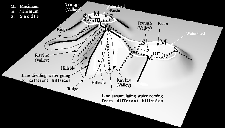
Figure 1: Sketch of some topographic features of a landscape.
Hydrology is a sub-discipline of Geomorphology, which is the science that analyzes the features on the surface of the earth. Geomorphology emerged as a branch of knowledge in the 19th century, a time where researchers tried to characterize mathematically the drainage pattern of a landscape. This is, to answer the question what is the feature that distinguish the slopelines that sketch the drainage network of a landscape?. Notice the high importance of this question in the civil engineering of numerous structures (railroad, highways, tunnels, industrial and residential areas, etc) as well as in water management and fire prevention (along valleys vegetation increases and therefore the risk of fire too). The attempt of characterizing mathematically the drainage pattern gave rise to several proposals, some of them clearly wrong. In fact, at the second half of the XIX century there was a scientific discussion about what is the right characterization [76, 11, 58, 8, 41, 42, 40, 9, 75]. Nowadays, the discussion still alives and has been imported to image analysis [45, 46, 55, 72]. However, from the viewpoint of artificial vision this is a void discussion (I believe) and the different characterizations have their own utility. Notice that, in most cases, we are not interested in hydrologic features of an image landscape but in features sketching interesting structures of the image, in a stable way and invariant under some transformations. Among this features are, of course, the ones constituting the topographic structure of the image [46, 65]: critical points, slopelines and level curves, their curvatures, the drainage pattern and the inverse drainage pattern. As we will see, these topographic entities are invariant under crucial transformations. Therefore, researchers in artificial vision have adopted the landscape model for images in order to extract its topographic structure.
In next sections, I will term the drainage pattern and any approximation to it as ridge/valley-like structures. I will denote as (inverse) drainage lines the (ridge) valley-like structures which are the special slopelines constituting the (inverse) drainage pattern.